


In the rapidly evolving world of architecture, construction, and engineering, precision is everything. Traditional surveying methods often fall short when dealing with complex structures, multi-level buildings, or large-scale infrastructure projects. This is where Lidar Scan to AutoCAD services come into play, providing a seamless bridge between reality and digital design for both small and large projects.
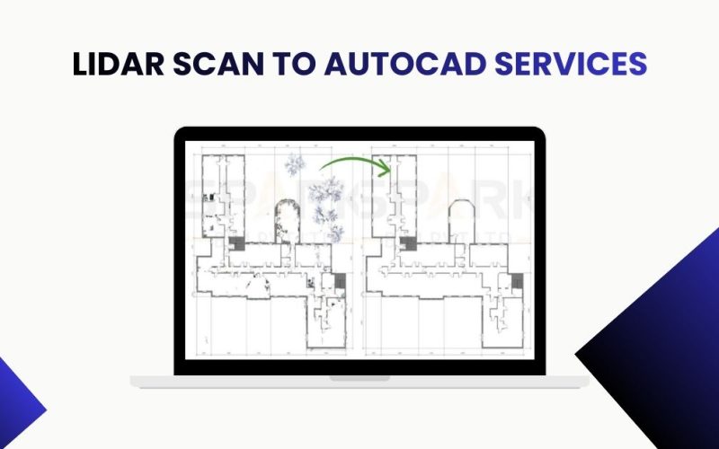
What is Lidar Scan to AutoCAD?
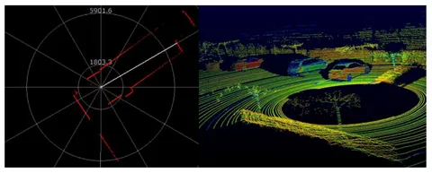
LiDAR, short for Light Detection and Ranging, is a cutting-edge technology that uses laser pulses to measure distances with incredible accuracy. By emitting thousands of laser beams per second, LiDAR captures highly detailed, three-dimensional representations of physical environments, from buildings to terrain.
When combined with AutoCAD, these massive point cloud datasets can be converted into precise 2D drawings or 3D models. This process, known as Lidar Scan to AutoCAD conversion, ensures that every element—from walls and ceilings to piping, ducts, and structural components—is represented with millimeter-level precision, making it ideal for design and construction planning.
Why LiDAR Scanning is Essential
-
Accuracy and Precision
LiDAR scanning captures millions of data points, often achieving millimeter-level accuracy, making it indispensable for projects where precision is critical, such as industrial plants or historical building restorations. -
Time Efficiency
Manual measurements are labor-intensive and prone to errors. LiDAR scanning dramatically reduces field time, enabling faster project delivery, faster decision-making, and minimizing delays in planning or construction. -
Comprehensive Data Capture
LiDAR captures surfaces, irregular shapes, hard-to-reach areas, and complex topography, creating a complete digital representation of the environment, which traditional methods cannot provide.
Benefits of Lidar Scan to AutoCAD Services
1. High-Quality 2D Drawings
AutoCAD is renowned for 2D drafting capabilities. By converting LiDAR point clouds, you obtain floor plans, elevations, and sections that accurately reflect real-world conditions. These precise drawings are crucial for renovation, remodeling, and ongoing facility management.
2. Seamless 3D Modeling
LiDAR data can also be converted into 3D CAD models, allowing architects and engineers to visualize structures in three dimensions, identify potential clashes, and optimize designs before construction begins. This reduces costly on-site errors and unnecessary change orders.
3. Improved Project Collaboration
Digital CAD models derived from LiDAR scans can be easily shared with stakeholders. This enhances collaboration among architects, engineers, contractors, and clients, improving communication, avoiding misinterpretation, and speeding up approvals.
4. Historical Preservation
For heritage buildings or cultural sites, LiDAR provides a non-intrusive method to document structures in detail. AutoCAD conversion ensures that historical features are digitally preserved for restoration, research, or digital archiving purposes.
The Lidar Scan to AutoCAD Process
The process involves several key steps to ensure high accuracy and usability:
-
Site Scanning
LiDAR scanners capture the environment, generating a point cloud that maps every surface, corner, and elevation in fine detail. -
Data Registration
Multiple scans from different angles are merged into a unified dataset to ensure complete coverage and accuracy, eliminating gaps or overlaps. -
Point Cloud Cleaning
Irrelevant data, noise, or redundant points are removed, making the dataset manageable and highly precise for CAD conversion. -
AutoCAD Conversion
CAD professionals trace or automatically extract features from the point cloud to create 2D drawings or detailed 3D models in AutoCAD for immediate use. -
Quality Assurance
The final CAD model undergoes rigorous quality checks to ensure accuracy, compliance with project requirements, and alignment with LOD (Level of Detail) standards.
Applications of Lidar Scan to AutoCAD Services
-
Architecture & Interior Design: Capture existing conditions for remodeling, extension, or renovation projects with full precision.
-
Civil Engineering: Survey roads, bridges, tunnels, and other infrastructure for planning, analysis, or maintenance.
-
Industrial Facilities: Map factories, plants, and warehouses for layout optimization, safety compliance, and operational efficiency.
-
Historical Preservation: Document cultural heritage sites and monuments accurately for research, restoration, and archiving purposes.
-
Construction Projects: Reduce design conflicts and on-site errors with as-built drawings derived from highly accurate LiDAR data.
Choosing the Right Service Provider
When outsourcing Lidar Scan to AutoCAD services, consider these key points:
-
Experience & Expertise: Select providers with proven CAD and LiDAR experience and a portfolio of successful projects.
-
Accuracy Standards: Ensure they adhere to international standards like ISO 19650 or BIM LOD compliance to guarantee precision.
-
Turnaround Time: Timely delivery is essential, especially for large-scale projects, without compromising quality.
-
Cost-Effectiveness: Affordable services should not compromise data quality, accuracy, or workflow efficiency.
Partnering with a reliable service provider ensures that LiDAR data is transformed into actionable CAD drawings, reducing project risks and improving workflow efficiency.
Future of LiDAR in CAD and BIM
LiDAR technology continues to evolve, providing higher-resolution data, faster scanning, and better integration with CAD and BIM workflows. When used alongside AutoCAD, it enables smarter designs, predictive maintenance, and digital twin creation. Businesses adopting Lidar Scan to AutoCAD services gain a competitive advantage by leveraging highly accurate data for design, construction, and management purposes.
Conclusion
Lidar Scan to AutoCAD services merge advanced technology with practical CAD applications. They offer unmatched accuracy, efficiency, and versatility for architects, engineers, and contractors. By converting real-world environments into precise AutoCAD drawings and models, these services minimize errors, optimize designs, and streamline project workflows.
Whether for industrial layouts, historical renovations, or infrastructure projects, LiDAR Scan to AutoCAD services provide clarity, accuracy, and efficiency. Investing in this technology today ensures smarter, faster, and more reliable project outcomes for tomorrow.