


Maps are much more than tools for navigation. They are windows into the past, capturing the perceptions, knowledge, and ambitions of societies throughout history. Historic maps offer a fascinating glimpse into how civilizations understood their world, revealing not only geographical information but also political boundaries, cultural values, and artistic expression. Studying these maps allows us to trace the evolution of cartography and to appreciate the artistry and craftsmanship that went into creating these remarkable documents.
The Origins of Mapmaking
The history of mapmaking stretches back thousands of years. Some of the earliest known maps were created by ancient civilizations such as the Babylonians, Egyptians, and Greeks. The Babylonians used clay tablets around 2300 BCE to depict land and irrigation systems. Their maps were primarily practical, aimed at agriculture and administration, yet they demonstrate a sophisticated understanding of spatial relationships. Similarly, the Egyptians produced maps for both administrative and funerary purposes, including layouts of cities, temples, and tombs.
In ancient Greece, cartography evolved into a more scientific endeavor. Scholars like Anaximander and Ptolemy introduced systematic approaches to mapping, incorporating concepts such as latitude and longitude. Ptolemy’s “Geographia,” written in the 2nd century CE, was especially influential, providing detailed instructions on how to map the known world. His work laid the foundation for European cartography for over a thousand years and influenced explorers during the Age of Discovery.
Medieval Maps and Their Unique Characteristics
During the medieval period, maps took on a distinctive character that reflected the worldview of the time. Many European maps from the Middle Ages, such as the famous Mappa Mundi of Hereford, were more symbolic than geographic. These maps often placed Jerusalem at the center of the world and depicted biblical stories, mythical creatures, and allegorical elements alongside geographic features. The purpose of these maps was not purely navigational; they were intended to convey religious and cultural knowledge.
Islamic scholars also made significant contributions to medieval cartography. Figures like Al-Idrisi created detailed maps that blended scientific observation with artistic presentation. Al-Idrisi’s “Tabula Rogeriana,” commissioned in the 12th century for the Norman King Roger II of Sicily, depicted the world with remarkable accuracy for its time, including regions of Europe, Africa, and Asia. These maps highlight the rich intellectual exchange across cultures during the medieval period and show how maps served both practical and scholarly purposes.
The Age of Discovery and the Expansion of Cartography
The 15th and 16th centuries marked the Age of Discovery, a period of exploration that dramatically expanded the geographic knowledge of the world. European explorers like Christopher Columbus, Ferdinand Magellan, and Vasco da Gama relied on maps to navigate uncharted waters. In turn, these voyages generated new cartographic information that reshaped maps across Europe.
Portolan charts emerged as an essential tool for maritime navigation. These maps, characterized by their detailed coastlines and rhumb lines indicating compass directions, allowed sailors to plot accurate courses. They were used extensively in the Mediterranean and later adapted for oceanic exploration. The introduction of the printing press further revolutionized mapmaking, allowing maps to reach a wider audience and standardizing geographic knowledge. By the 16th century, cartographers like Gerardus Mercator and Abraham Ortelius were producing maps and atlases that combined scientific accuracy with aesthetic elegance. Mercator’s projection, introduced in 1569, became a standard for nautical navigation, while Ortelius’ “Theatrum Orbis Terrarum” is often considered the first modern atlas.
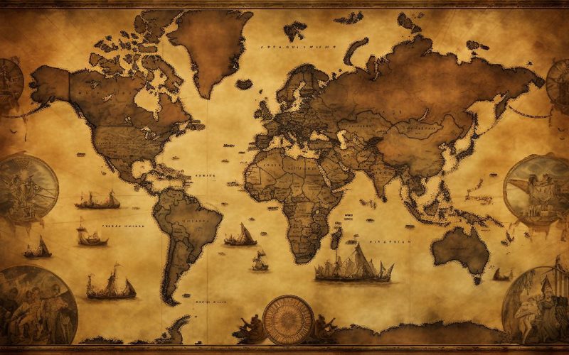
Artistic and Decorative Aspects of Historic Maps
Historic maps are as much works of art as they are geographic tools. Cartographers often adorned maps with elaborate borders, illustrations of ships, sea monsters, and exotic wildlife. These embellishments served both decorative and informational purposes, providing insights into the fears, curiosities, and knowledge of the time. For example, maps of the New World often depicted fantastical creatures or exaggerated depictions of native peoples, reflecting the imagination and biases of European explorers.
The artistry of maps extended beyond illustrations. Many maps were hand-colored, printed on luxurious materials such as vellum or parchment, and sometimes bound into ornate atlases. This combination of functionality and beauty elevated maps to prestigious objects collected by royalty, scholars, and wealthy patrons. Today, historic maps are highly valued by collectors and museums not only for their geographic information but also for their artistic merit.
Mapping Advances and the Role of Technology
Technological advancements have always driven changes in cartography. The invention of the compass, the astrolabe, and more accurate measuring instruments allowed mapmakers to depict the world with greater precision. The introduction of triangulation in the 16th century enabled surveyors to create more accurate land maps, improving urban planning, military strategy, and territorial administration.
In the 18th and 19th centuries, cartography became increasingly scientific. The use of longitude and latitude became standard, and mapmaking institutions, such as the Ordnance Survey in Britain, began producing systematic maps for entire countries. These developments marked a shift from maps as artistic or symbolic objects to tools grounded in empirical observation and measurement. However, even in this period, maps retained aesthetic elements, demonstrating that functionality and visual appeal were not mutually exclusive.
Maps as Historical Documents
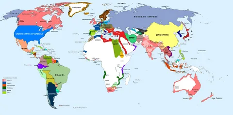
Historic maps serve as valuable records of political, cultural, and environmental history. They reveal how borders and territories changed over time, reflecting wars, treaties, and colonization. For example, maps of Europe before and after the Napoleonic Wars illustrate shifts in national boundaries, while colonial maps of Africa and Asia show the extent of European imperial influence.
Maps also provide insights into the development of cities, trade routes, and natural resources. Early maps often depicted rivers, mountains, and other topographic features critical for settlement and transportation. By comparing maps from different periods, historians can trace urban expansion, agricultural practices, and the impact of human activity on landscapes. In this way, maps are not only tools for navigation but also windows into the socioeconomic and environmental history of regions.
Collecting and Preserving Historic Maps
Collecting historic maps has become a popular pursuit among enthusiasts, scholars, and institutions. Antique maps are sought for their rarity, historical significance, and visual appeal. Specialized auction houses, galleries, and online marketplaces offer collectors the opportunity to acquire maps from different periods and regions. High-quality reproductions also allow broader audiences to appreciate these artifacts without compromising the originals.
Preservation is crucial, as historic maps are often fragile and susceptible to damage from light, humidity, and handling. Museums and libraries employ specialized techniques, including acid-free storage, controlled lighting, and digital archiving, to protect these treasures for future generations. Digital technologies have also enabled widespread access to historic maps, allowing researchers and the public to study and explore maps that were previously inaccessible.
Notable Historic Maps and Their Significance
Several historic maps stand out for their impact on cartography and historical understanding. The Tabula Rogeriana by Al-Idrisi remains one of the most detailed medieval maps of the known world. Gerardus Mercator’s world map and projection revolutionized navigation and influenced mapmaking for centuries. The Mappa Mundi of Hereford provides a unique perspective on medieval cosmology and worldview. Each of these maps tells a story not only about geography but also about the culture, knowledge, and imagination of the society that produced it.
Exploratory maps of the New World, including those created by explorers like Amerigo Vespucci and Juan de la Cosa, document the expansion of geographic knowledge during the Age of Discovery. Similarly, maps produced during the Enlightenment reflect the growing emphasis on empirical observation, scientific rigor, and global awareness. Studying these maps provides a multifaceted view of human history and our evolving understanding of the planet.
The Cultural and Educational Value of Historic Maps
Historic maps serve as powerful educational tools, illustrating the intersection of geography, history, and art. They encourage critical thinking, helping students and scholars understand how knowledge is constructed and communicated. By examining historic maps, learners can explore the perspectives, biases, and priorities of past societies.
Culturally, maps reinforce identity and heritage. They document territorial claims, migrations, and trade networks, connecting people to their historical roots. In addition, historic maps inspire curiosity and creativity, inviting viewers to imagine the world as it was perceived centuries ago. Whether displayed in museums, used in classrooms, or preserved in private collections, historic maps continue to enrich our understanding of human civilization.
Conclusion: The Enduring Legacy of Historic Maps
Historic maps remain invaluable artifacts that bridge the past and present. They reveal the evolution of geographic knowledge, the creativity of cartographers, and the cultural and political contexts of their time. Beyond their practical applications, maps are a testament to human curiosity, exploration, and the desire to understand the world. Studying and preserving historic maps allows us to appreciate not only their functional value but also their artistic, cultural, and educational significance. As windows into history, they remind us that the way we see and understand the world is always shaped by the perspectives of those who chart it.